Philippine Sea plate
Philippine Sea plate unified based on the velocity structures by seismic tomography, seismicity, focal mechanisms, seismic reflection and refraction survey, receiver function analysis.
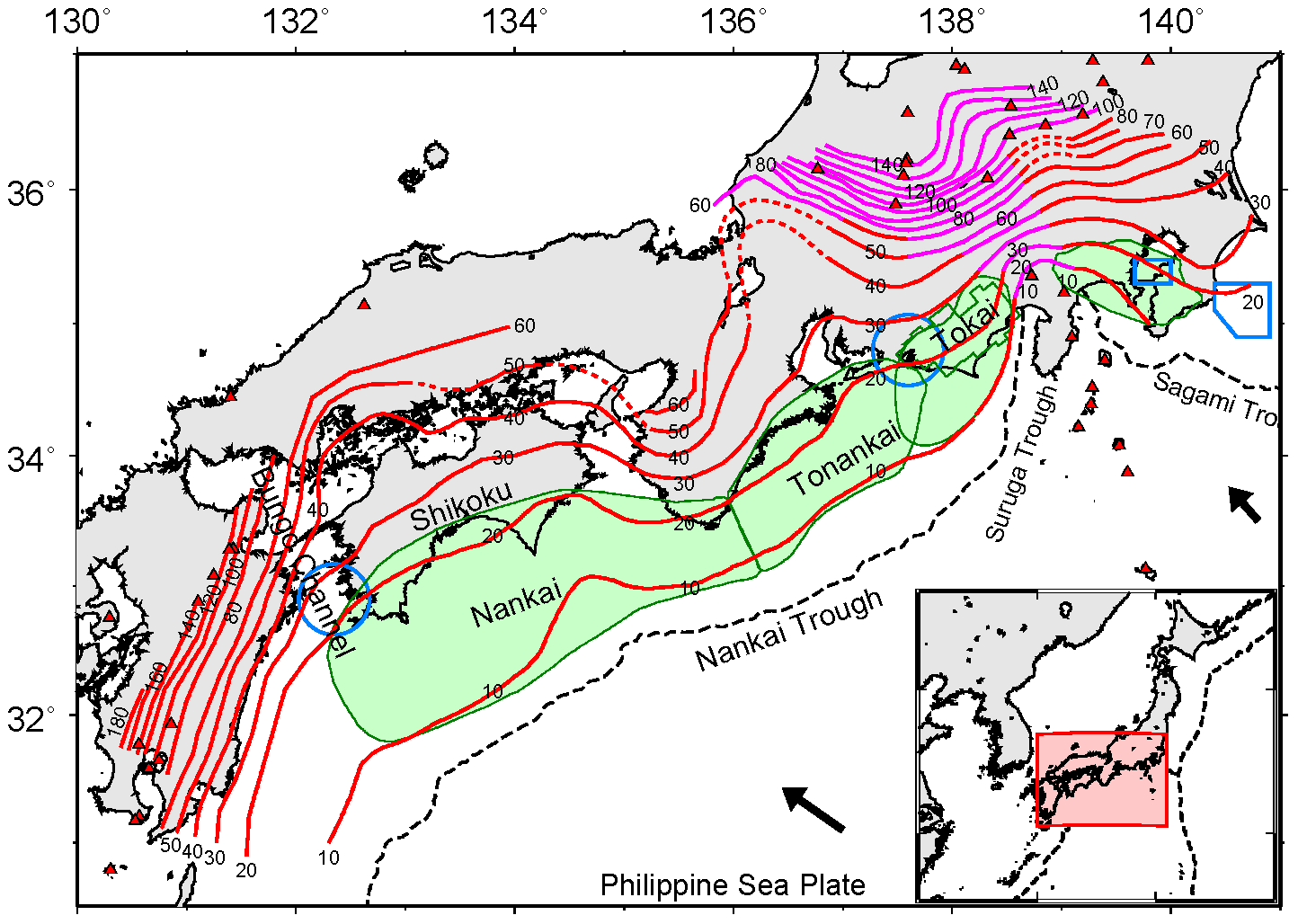
Figure 1. Depth contour map of the upper boundary of the Philippine Sea slab.
PDF
1, 3, 9 4 10 7, 13 2, 15 5, 6, 8, 11, 12 14
References
Baba, T., Y. Tanioka, P. R. Cummins, and K. Uhira (2002), The slip distribution of the 1946 Nankai earthquake estimated from tsunami inversion using a new plate model, Phys. Earth Planet. Inter., 132, 59-73.
Central Disaster Management Council (2001), Report of the specialized investigation committee about Tokai earthquake (in Japanese), http://www.bousai.go.jp/jishin/chubou/20011218/siryou2-2.pdf, (2006-11-15).
Hirose, F., J. Nakajima, and A. Hasegawa (2008), Three-dimensional seismic velocity structure and configuration of the Philippine Sea slab in southwestern Japan estimated by double-difference tomography, J. Geophys. Res., 113, B09315, doi:10.1029/2007JB005274.
Hirose, F., J. Nakajima, and A. Hasegawa (2008a), Three-dimensional velocity structure and configuration of the Philippine Sea slab beneath Kanto district, central Japan, estimated by double-difference tomography, J. Seism. Soc. Jpn., 2, 60, 123-138. (in Japanese with English abstract)
Hirose, H., K. Hirahara, F. Kimata, N. Fujii, and S. Miyazaki (1999), A slow thrust slip event following the two 1996 Hyuganada earthquakes beneath the Bungo Channel, southwest Japan, Geophys. Res. Lett., 26, 3237-3240.
Hirose, I., I. Kawasaki, Y. Okada, T. Sagiya, and Y. Tamura (2000), A silent earthquake of December 9, 1989, in the Tokyo Bay, as revealed by the continuous observation of crustal movements in the southern Kanto district, central Japan, J. Seism. Soc. Jpn., 2, 53, 11-23. (in Japanese with English abstract)
Matsumura, S. (1997), Focal zone of a future Tokai earthquake inferred from the seismicity pattern around the plate interface, Tectonophys., 273, 271-291.
Miyazaki, S., P. Segall, J. J. McGuire, T. Kato, and Y. Hatanaka (2006), Spatial and temporal evolution of stress and slip rate during the 2000 Tokai slow earthquake, J. Geophys. Res., 111, B03409, doi:10.1029/2004JB003426.
Nakajima, J., and A. Hasegawa (2007), Subduction of the Philippine Sea plate beneath southwestern Japan: Slab geometry and its relationship to arc magmatism, J. Geophys. Res., 112, B08306, doi:10.1029/2006JB004770.
Nakajima, J., F. Hirose, and A. Hasegawa (2009), Seismotectonics beneath the Tokyo metropolitan area, Japan: Effect of slab-slab contact and overlap on seismicity, J. Geophys. Res., 114, B08309, doi:10.1029/2008JB006101.
Ozawa, S., S. Miyazaki, Y. Hatanaka, T. Imakiire, M. Kaidzu, and M. Murakimi (2003), Characteristic silent earthquakes in the eastern part of the Boso peninsula, Central Japan, Geophys. Res. Lett., 30, 1283, doi: 10.1029/2002GL016665.
Sagiya, T (2004), Interplate coupling in the Kanto district, Central Japan, and the Boso peninsula silent earthquake in May 1996, Pure Appl. Geophys., 161, 2327-2342.
Wald, D. J., and P. G. Somerville (1995), Variable-slip rupture model of the great 1923 Kanto, Japan, earthquake: Geodetic and body-waveform analysis, Bull. Seism. Soc. Am., 85, 159-177.
Wei, D., and T. Seno (1998), Determination of the Amurian plate motion, in "Mantle dynamics and plate interactions in East Asia", Geodynamics. Series, 27, ed. by M. F. J. Flower, S. L. Chung, C. H. Lo, and T. Y. Lee, pp. 337-346, AGU, Washington D. C.
Earthquake Research Committee (2001), Long-term evaluation of earthquakes in the Nankai trough (in Japanese), http://www.jishin.go.jp/main/chousa/01sep_nankai/index.htm, (2006-11-15).