Year Key words |
TITLE
Authors
WGNE Link
|
Contens (part of reports). |
2003
Line-shaped precipitation systems (Analysis)
線状降水帯の構造
|
NUMERICAL STUDY OF THE SHAPES AND MAINTENANCE MECHANISMS OF MESO-β SCALE LINE-SHAPED PRECIPITATION SYSTEM IN THE MIDDLE-LATITUDES
Hiromu Seko, Hajime Nakamura
WGNE Link |
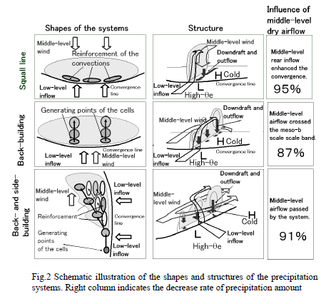
Besides the precipitation systems of the SL type and the BB type that have been
investigated so far, it was found that the precipitation system of the BSB type
that often caused the heavy rainfall exists. As for the environment of the systems,
when the direction of the middle-level wind is opposite, same and perpendicular
to that of the low-level inflow, the precipitation systems of the SL type,
the BB type and the BSB type develop.
|
2003
Data assimilation of Radar and GNSS data (4DVar)
GNSSデータの同化
|
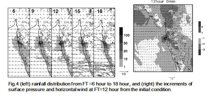
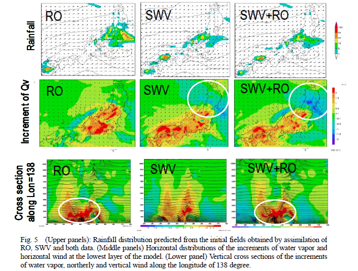
DATA ASSIMILATION EXPERIMENTS IN NERIMA HEAVY RAINFALL
- HOW USEFUL ARE DOPPLER RADAR RADIAL WIND AND GPS-DERIVED WATER VAPOR? -
Hiromu Seko, Takuya Kawabata, Tadashi Tsuyuki,Hajime Nakamura, Ko Koizumi, Tetsuya Iwabuchi
WGNE Link |
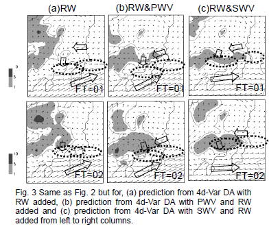
The assimilation of RW data of the Doppler radar and GPS-derived water vapor data was performed and their
impacts on the prediction of the precipitation were investigated. When both data was used as the input
data of 4D-Var DA, the prediction of the precipitation was improved significantly.
It was also shown that the SWV data has the potential to reproduct the vertical structure of
the water vapor. |
2005
Data assimilation of Radar data in the typhoon case (4DVar)
レーダ動径風の同化、台風への適用
|
Assimilation of Radial Wind measured by Doppler radar to Typhoon HIGOS
Masaru Kunii, Hiromu Seko
WGNE Link
|
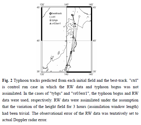
The typhoon's track predicted from the RW-assimilated field was close to that of the typhoon bogus case.
This result indicates that actual observed RW data can improve the forecast as much as the
typhoon bogus data. |
2005
Data assimilation of Radar and GNSS data (3DVar) + Cloud analysis
3DVarと雲解析による局地的大雨の同化実験
|
Data Assimilation Experiments of Nerima Heavy Rainfall
Hiromu Seko, Takuya Kawabata, Tadashi Tsuyuki
WGNE Link
|
To reproduce the intensity of heavy rainfall, the non-hydrostatic model of JMA (NHM) that predicts water substances explicitly was used,
and the RW and PWV was assimilated into NHM by 3-dimensional data assimilation system (NHM3dVarDAS).
|
2006
Data assimilation of Wind Profiler Refractivity data (4DVar)
4DVarによる局地的大雨の同化実験 |
Data Assimilation Experiments of Vertical Gradient of Refractivity Observed by Wind Profiler Network
Hiromu SEKO, Jun-ichi FURUMOTO, Masahiro SASAOKA, Kazuo SAITO, Tadashi TSUYUKI
WGNE Link
|
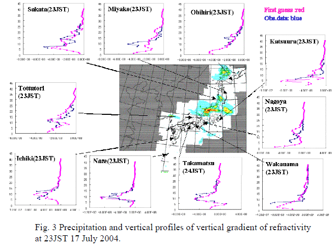
The vertical refractivity profiles were estimated from the WINDAS data and the impact of this data was
investigated by using the Meso-4DVar Data assimilation system of JMA (Koizumi et al., 2005). |
2006
Data assimilation of LEO refactivity tangent point data (4DVar)
掩蔽データの同化(タンジェント点)
|
Data Assimilation Experiments using CHAMP Refractivity Data
Hiromu SEKO, Yoshinori SHOJI, Masaru KUNII, Kazuo SAITO, Yuichi AOYAMA
WGNE Link
|
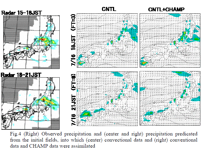
When the CHAMP-derived refractivity data was assimilated, the precipitation regions became similar
to the observed ones and the precipitation intensity also became more intense. Thus, the CHAMP-derived
data has the potential to improve the rainfall forecast.
|
2006
Line-shaped precipitation systems (Analysis)
線状降水帯の解析
|
Line-shaped Convective Band Developed Over the Osaka Plain
Hiromu SEKO, Yoshimasa, KUMAHARA, Kazuo SAITO
WGNE Link
|
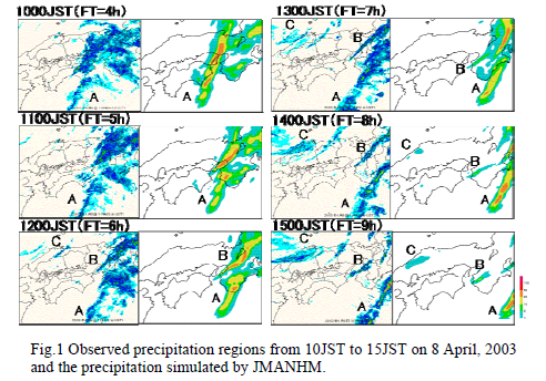
The precipitation distribution is compared with the observed one, and then the
structure and moving speed of the band are investigated using the outputs of the numerical models.
|
2007
Data assimilation of LEO refactivity path-data (nonlocal data) data (4DVar)
Vertical correlation of observation error
掩蔽データの同化(視線データ)、鉛直誤差相関の考慮
|
Data Assimilation Experiments using CHAMP Refractivity Data
Hiromu SEKO, Yoshinori SHOJI, Masaru KUNII, Kazuo SAITO, Yuichi AOYAMA
WGNE Link |
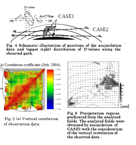
When the path-averaged value was assimilated, the impact of CHAMP data became smaller. The vertical correlation of
the path data is also considered in the same way as the tangent point. When the path-averaged refractivity was assimilated
with consideration of the vertical correlation of observation error, the precipitation became stronger and became similar
to the observed one. |
2008
Data assimilation of COMSMIC refactivity path-data data (4DVar)
COSMICの掩蔽データの同化
|
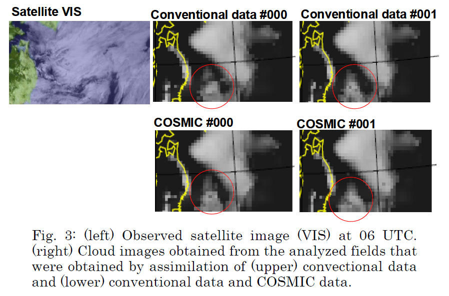
Assimilation experiments using COSMIC occultation data
Hiromu Seko, Yoshinori Shoji, Masaru Kunii, Jun-ichiro Furumoto, and Toshitaka Tsuda
WGNE Link |
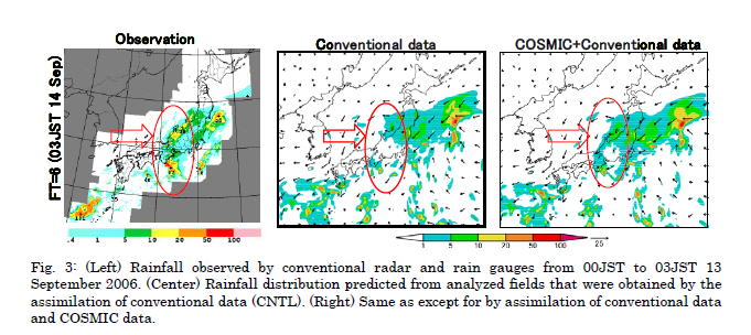
When the forecast was performed from the analysis field obtained by the assimilation of COSMIC data,
the rainfall region over central Japan was expanded. The rainfall region extending from central Japan to northeast,
which is marked by circles, becomes similar to the observed one. This result indicates that COSMIC data improves the rainfall forecast. |
2008
Potential parameter of tornado formation, Meso-ensemble experiment
竜巻の発生ポテンシャルの確率予報
|
Meso-ensemble experiments on potential parameter of tornado formation using JMANHM
Hiromu Seko, Kazuo Saito, Masaru Kunii, Tabito Hara, and Munehiko Yamaguchi
WGNE Link |
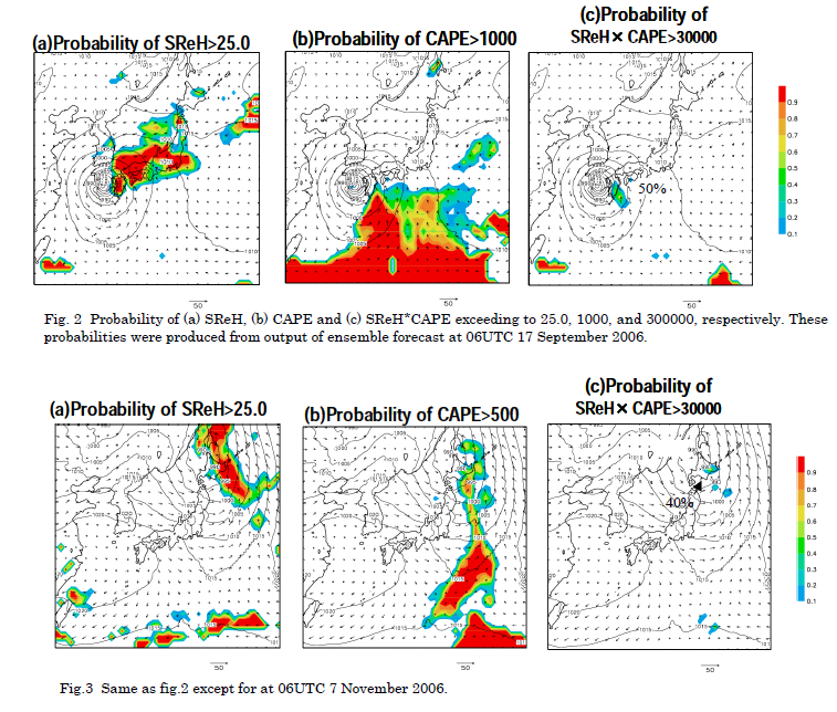
As for the products of CAPE and SReH, the region where the probability of this product exceeding 30,000 is more
than 50%, existed only at the eastern part of Kyushu. This result indicates that the ensemble forecast
is useful, when the product of CAPE and SReH is used as potential parameter of the tornado formation. |
2008
Experiments of B08RDP
北京オリンピックのTier-2実験
|
Tier-2 downscale experiments of B08RDP
Hiromu Seko, Kazuo Saito, and Masaru Kunii
WGNE Link |
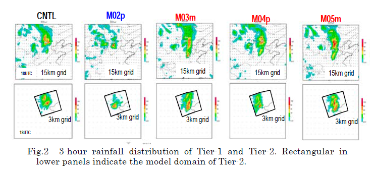
Rainfall amount was also similar to that of Tier-1, because the rainfall amount was
also controlled by the boundary of domain. On the other hand, the maximum rainfall amount is larger than that of Tier-1.
The rainfall region exceeding 1mm/3hour was smaller than Tier-1. These results indicated the rainfall region of Tier2 was
more localized. |
2008
NHM-LETKF(Influence of the resolution)
LETKFの同化実験、解像度の影響
|
Japan area ensemble forecast using NHM-LETKF
Hiromu Seko, Takemasa Miyoshi, Masaru Kunii, and Kazuo Saito
WGNE Link |
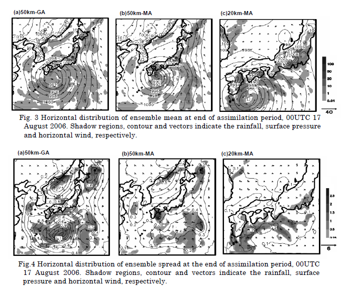
As the preliminary experiment, influences of the horizontal grid interval, and the horizontal
resolution of observation data over the results of ensemble forecast are investigated. |
2008
Analysis Mumbai heavy rainfall, Strong wind case in Java Sea
ムンバイの大雨の再現実験(1)
|
Numerical simulation of severe weather events in South/Southeast Asia using NHM
Hiromu SEKO, Syugo HAYASHI, Masaru KUNII and Kazuo SAITO
WGNE Link |
Numerical simulations of the strong wind and heavy rainfall events were
performed by using NHM of JMA to investigate the usefulness of it for the prediction of weather phenomena
in the tropical region (Strong wind case in the Java Sea, Munbai Heavy rainfall). Preliminary results on
these events were presented. |
2009
Synergistic effect, Occultation (CHAMP) and Ground GPS
掩蔽データと地上GNSSの相乗効果
|
Synergistic effect of the assimilation of Radio occultation data and ground-based GPS data
Hiromu Seko, Kazuo Saito, Masaru Kunii, and Yoshinori Shoji
WGNE Link |
RO is high-resolution data in the vertical direction. However, there is little information in the horizontal direction
because the average of the path is assimilated. On the other hand, SWV/PWV is high-resolution data in
the horizontal direction. However, they have little information in the vertical direction. We focus on the refractivity data
of CHAMP and GPS-derived SWV to investigate the synergistic impact of these data. |
2009
Line-shaped rainfall system, LETKF, assimilation of GPS data
利賀川水難事故の線状降水帯、GPSデータ同化
|
Data assimilation experiment of the Kobe thunder storm by using NHM-LETKF
Hiromu Seko, Kazuo Saito, Masaru Kunii, and Takemasa Miyoshi
WGNE Link |
The ensemble forecast was performed to reproduce this rain band by the assimilation of the GPS-derived
precipitable water vapor (PWV). The object of this paper is to show the usefulness of the ensemble forecast and
the impact of the PWV data on the forecast of heavy rainfall. |
2009
Munbai heavy rainfall, Airflow structure
ムンバイの大雨の再現実験(2)
|
STRUCTURE OF THE REGIONAL HEAVY RAINFALL SYSTEM THAT OCCURRED IN MUMBAI, INDIA, ON 26 JULY 2005
Hiromu SEKO, Syugo HAYASHI, Masaru KUNII, and Kazuo SAITO
WGNE Link |
The heavy rainfall that occurred in Mumbai on 26th July 2005 produced a rainfall amount exceeding 944.2 mm in 24 hours
(Bohra et al, 2005). The rainfall region observed by the TRMM satellite revealed that the horizontal scale of this rainfall
event was several tens of kilometers. The airflow structure was investigated with the outputs of the Non-hydrostatic model
with the horizontal grid interval of 1 km. |
2010
Assimilation of GPS Occultation data, Side-looking OSSE
掩蔽のサイドルッキングデータのOSSE
|
Data Assimilation of Side-looking Radio Occultation by Observing System Simulation Exper iment
Seko, H., T. Tsuda, N. Yoshida and Y.-H. Kuo
WGNE Link |
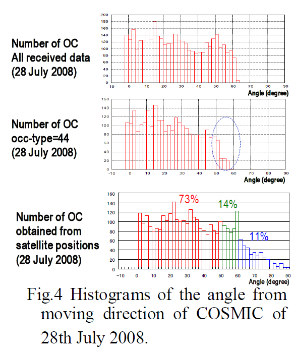
If slant path data is used in the assimilation, occultation data of which the angle from the moving direction of LEO satellite
is large, can be used in the assimilation. In general, impact of RO data is weak because the slant path data stretches
for several hundred kilometers. For this reason, the total number of assimilated data should be increased by using 'side-looking'
data. In this study, impact of side-looking data is investigated by OSSE. |
2010
Local heavy rainfall, Ensemble experiment
大阪の局地的大雨のアンサンブル実験、アンサンブルの有効性
|
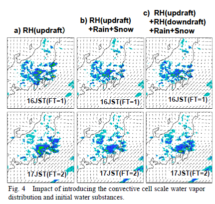
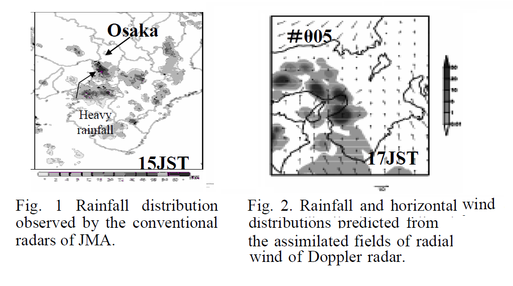
Ensemble experiments of local heavy rainfall that occurred in Osaka, Japan, 5 September 2008
HIROMU SEKO, MASARU KUNII, TAKUYA KAWABATA and TAKEMASA MIYOSHI
WGNE Link |
Even if the convergence surrounding local heavy rainfalls is not reproduced by deterministic forecast,
some members of ensemble forecasts can produce the convergence. In this study, the usefulness of ensemble
forecast for reproduction of the mesoscale convergence is shown. |
2010
Gravity wave, Generation mechanisms of convection cells
重力波による対流の発生メカニズム
|
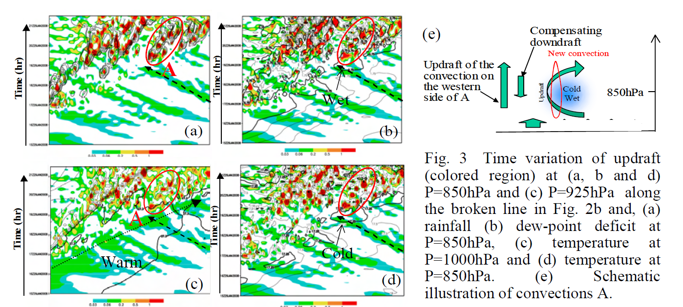
Generation mechanisms of convections by gravity waves
HIROMU SEKO, SYUGO HAYASHI and KAZUO SAITO
WGNE Link |
Because convective storms sometimes cause mudslides or floods, it is important to understand the generation and
developmental mechanisms of the convections. In this study, the generation mechanisms of the convections
by gravity waves (GWs) were investigated using the outputs of Nonhydrostatic model (NHM). |
2011
LETKF Nested System, Cloud Resolving Model
LETKFネストシステム、視線データの同化実験
|
Development of an LETKF Nested System for a Cloud Resolving Model
Hiromu Seko, Tadashi Tsuyuki and Kazuo Saito
WGNE Link |
An LETKF nested system, which modifies the large scale convergence by assimilation of
conventional data and reproduces intense convection by assimilation of high resolution data,
such as GPS PWV data, is explained and the preliminary results are also reported. |
2011
wind profiler, vertical gradient of refractive index data
プロアイラーの水蒸気情報の同化実験
|
Data Assimilation Experiments of Vertical Gradient of Refractive Index Observed by Wind Profilers
Hiromu Seko, Kazuo Saito and Toshitaka Tsuda
WGNE Link |
The vertical gradients of refractivity observed by WINDAS were assimilated by the 3-dimensional data
assimilation system (JNoVA0) for non-hydrostatic model (NHM), and the impact of vertical gradients of
refractivity on the forecast of intense rainfall is presented. |
2012
GPS water vapor, synergistic effects of GPS water vapor data and wind data
局地的大雨の再現実験、地上GNSSとレーダの水平風の相乗効果
|
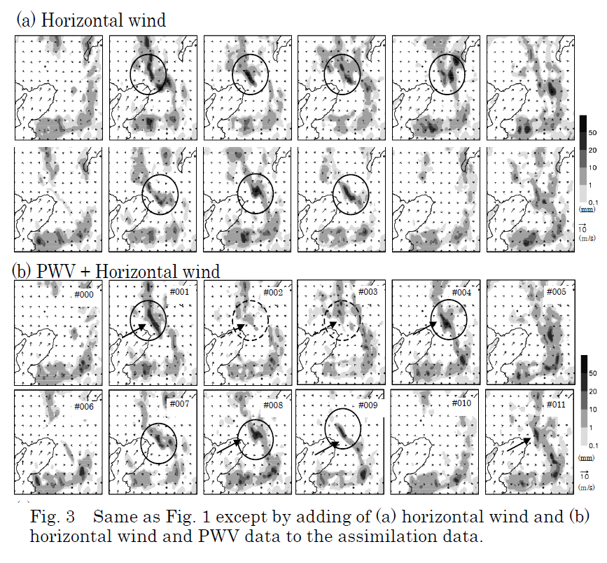
Improvements of the nested LETKF system
- Impacts of GPS water vapor data and synergistic effects of GPS water vapor data and wind data -
Hiromu Seko, Tadashi Tsuyuki, and Kazuo Saito
WGNE Link |
The impacts of the SWV and the synergistic effect of simultaneous assimilation of Doppler radar data and
GPS water vapor data (PWV or SWV) are investigated, as well as the GPS-PWV data and Doppler radar data. |
2012
low-level convergence, generation of local heavy rainfall
収束の再現による雷雨発生予測実験
|
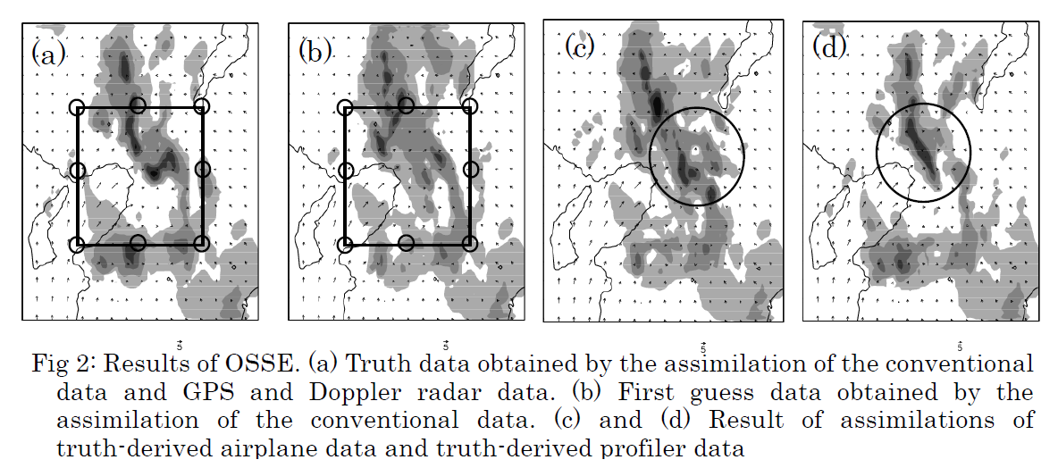
Impacts of the low-level convergence data on the local heavy rainfall
Hiromu Seko, Kazuo Saito, Osamu Suzuki and Ahoro Adachi
WGNE Link |
The observation data of airplanes and of the low-level profilers in the urban area, which have the information
of the horizontal convergence of low-level winds, were assimilated. Their impacts were investigated
by checking that the generation and development of the thunderstorms were reproduced by the assimilation
of these data. |
2012
Quasi-Zenith Satellite, Observation System Simulation Experiments
準天頂衛星による局地的大雨のOSSE
|
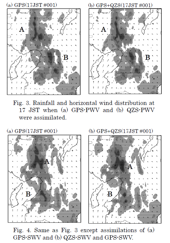
Observation System Simulation Experiments of Quasi-Zenith Satellite
Hiromu Seko, Satoshi Kogure and Toshitaka Tsuda
WGNE Link |
The potential of improvements on rainfall forecasts by Quasi-Zenith Satellite, whose position stays around the zenith direction and
in low-level elevations for long periods is investigated
by the observation system simulation experiments. |
2012
Yamase, nested LETKF system
LETKFネストシステム、ヤマセの再現実験
|
Ensemble forecast experiments of 'Yamase' that occurred on 31st July 2011
Hiromu Seko, Yasumasa Kodama and Toshitaka Tsuda
WGNE Link |
Ensemble forecasts of 'Yamase' were conducted by using the nested LETKF system. The comparisons with the
observation data are shown in this report. |
2013
Tornado, two-way nested-LETKF system, factors for the generations of intense vortices
竜巻に伴う渦の発生要因、アンサンブル予報の高度な利用法
|
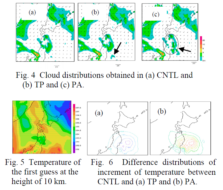
Data Assimilation Experiments of Tornado occurring on 6th May 2012
Hiromu SEKO, Kazuo SAITO, Tadashi TSUYUKI, Masaru KUNII and Takemasa MIYOSHI
WGNE Link |
A tornado that occured on 6th May 2012 in the Kanto Plain was reproduced by using a two-way nested-LETKF system
with horizontal resolutions of 2 km and 15 km. Downscaling forecasts with horizontal grid intervals of 350 m
and 50 m that can create intense vortices were also performed. The factors for the occurances of intense vortices
that were investigated by the outputs of downscale experiments are shown. |
2014
Radar refractivity
レーダによる屈折率の時間変化の同化実験
|
Data Assimilation Experiments of Refractivity Observed by JMA Operational Radar
Hiromu SEKO, Yoshihisa KIMATA, and Toshitaka TSUDA
WGNE Link |
The preliminary results of data assimilations, in which 'temporal increments of refractivity' are used in
producing initial conditions of numerical forecasts, will be presented. |
2015
Radio Occultation Refractivity Data
掩蔽データのLETKFによる同化実験
|
Data Assimilation Experiments of Radio Occultation Refractivity Data by using a Mesoscale LETKF System
Hiromu SEKO and Toshitaka TSUDA
WGNE Link |
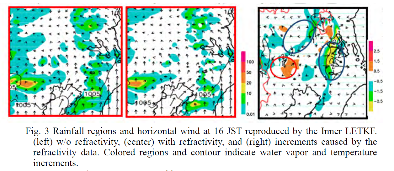
The assimilation result of this RO data indicated that the differences between the first guess and the observation
may have changed when the large mesoscale perturbation of refractivity existed around the tangent points,
and that the temperature and water vapor were modified more widely when the path-averaged refractivity was assimilated. |
2016
SSR mode-s downlink data, LETKF
航空機モードSダウンリンクデータのLETKFによる同化実験
|
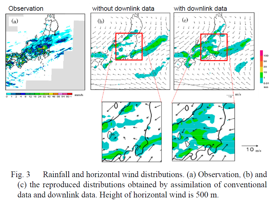
Data assimilation experiment of SSR mode-s downlink data
Hiromu Seko, Takayuki Yoshihara, and Atsushi Senoguchi
WGNE Link |
The impact of downlink data on heavy rainfall that occurred in the Kanto region, Japan on
26th August 2011 was investigated with the data assimilation systems by using a Local Transform Ensemble Kalman Filter. |
2018
SSR mode-s downlink data, Meso-NAPEX system
航空機モードSダウンリンクデータメソNAPEXによる同化実験
|
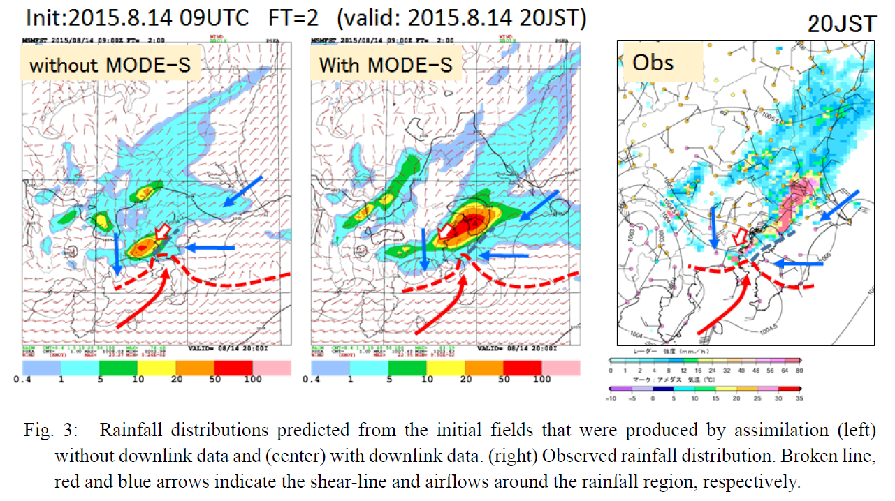
Data assimilation experiments of SSR mode-s downlink data using Meso-NAPEX system of JMA
Hiromu Seko, Ko Koizumi, Takayuki Yoshihara, Atsushi Senoguchi and Tadashi Koga
WGNE Link |
The quality of downlink data were investigated by the comparison with the operational mesoscale analysis data of
JMA, and the data assimilation experiments of downlink data were conducted with the meso-NAPEX system. |