GPSのF3解の再解析値は1996年3月からであり、この頃設置されたGPS観測点が多かったため、紀伊水道付近の非定常変位を最初に見たときは、設置後の一時的な不安定かと思った。あるとき紀伊水道付近の非定常変位が複数の観測点に見られることに気が付き、これらが長期的なスロースリップによる変位だと考えた。国土地理院からF2解に準拠した手法で解析した1994年秋からのデータをいただいてつなげると、スロースリップの開始時期が明らかになった。
要旨
We present a long-term slow slip event from 1996 to 1997 in the Kii Channel along the Nankai Trough in southwestern Japan that has not been reported previously. The long-term slow slip event had a moment magnitude Mw 6.7 and a duration of 1 to 1.5 years. The magnitude of the event was smaller than those of the Tokai (Mw 7.1) and the Bungo Channel (Mw 7.0 to 7.1) events along the Nankai Trough. The slip was located slightly shallower than the depth of the low-frequency earthquakes around the Kii Channel. Long-term slow slips have been identified in various regions along the Nankai Trough, except in the Kii Peninsula. Unveiling the history of long-term slow slips is expected to contribute to an understanding of plate boundary characteristics as well as to the prediction of large earthquakes along the Nankai Trough.
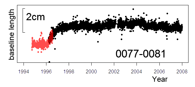
図 岡山県(940077)と徳島県(940081)の間の基線長変化。黒はF3解、赤はF2解。
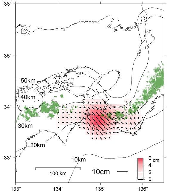
図 推定されたすべり分布。緑の丸印は低周波地震。
|