豊後水道の長期的スロースリップに関する過去の水準、潮位データの解析が一段落したので、次に四国の中東部について調査を行った。水準、潮位とも1977〜1980年頃に高知付近が隆起しているという解析結果だった。その他にも四国東部で非定常な隆起と水平変位が見つかったが、GPS観測がある期間にも観測されているので、次の機会に詳しく解析することにした。
要旨
We extracted unsteady vertical crustal deformations in the Shikoku region before GPS deployment using leveling and sea-level data. GPS-derived, steady-state vertical displacements related to ongoing subduction of the Philippine Sea plate were subtracted from the vertical displacements observed by leveling surveys. Monthly mean sea-level data were corrected for atmospheric pressure and hydrographic effects. As a result, we found an upheaval of 4-5 cm near Kochi City from 1977 to 1980 in both the leveling and sea-level data. This may represent a crustal deformation caused by a long-term slow slip event on the plate boundary.
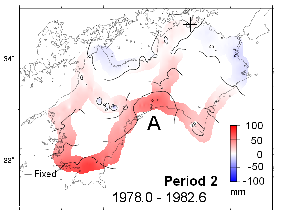
図 水準測量による1978.0〜1982.6年の非定常地殻上下変動。プレート沈み込みに伴う定常的な地殻変動を差し引いたもの。豊後水道の長期的スロースリップに伴う四国南西部の隆起の他に、高知付近(A)にも隆起域が見られる。
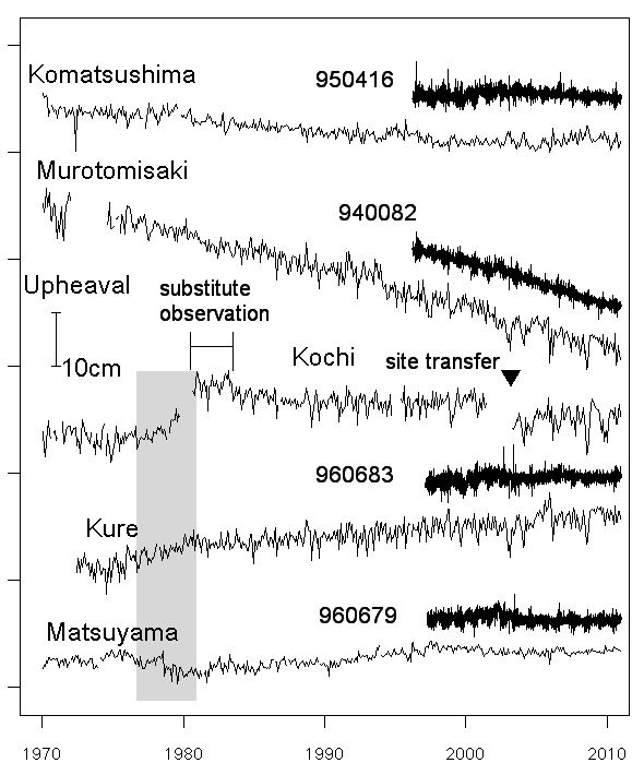
図 津村(1963)の方法により補正した月平均潮位変化(上が地盤隆起)と、潮位観測点最寄のGPS観測点の940083高知に対する比高変化。グレーの期間に高知と久礼で隆起に対応する変化が見られる。
|