要旨
2000年秋に始まった東海地域長期的スロースリップのすべり領域の真上に近い舞阪検潮所の潮位データに、スロースリップによる地盤の隆起を示す潮位変化が現れている。舞阪の潮位データについて過去の記録を調べたところ、今回と同様な変化が1980〜1982年と1988〜1990年頃にも認められ、これらの時期にも長期的なスロースリップが発生していた可能性がある。
We report that tide gauge records at Maisaka, situated near Lake Hamana in the south coast of Tokai area, show upheaval of the land due to the Tokai slow slip that has started in the fall of 2000. Lowering of the sea level is also seen in the records during the periods of 1980-1982 and 1988-1990. We think it is very probable that a slow slip occurred in the period of 1988-1990, because there are some other evidences to support the conjecture: (1) A change similar to that in recent years was observed by the tiltmeter at Mikkabi on the northwestern shore of Lake Hamana, (2) the spatial pattern of vertical movement in the period of 1988-1990 deduced from leveling measurements was similar to that in recent years, and (3) the seismic activity in the slab near Lake Hamana decreased conspicuously in both periods of 1988-1990 and since 2000. As for the change in the period of 1980-1982, it is possible that it might be caused by a slow slip. However, we cannot say that with confidence for the present because observations at that time were not enough compared to the later periods.
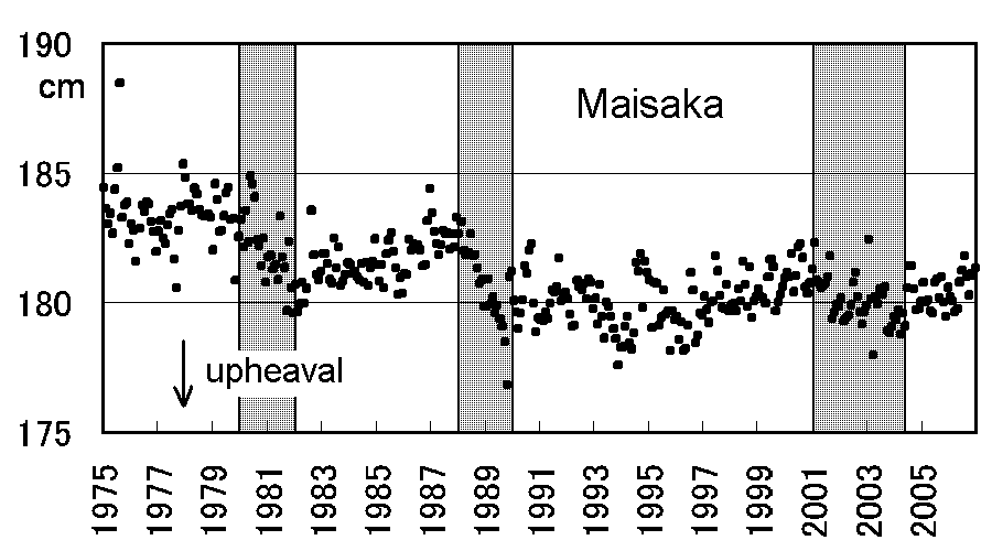
図 舞阪における潮位変化(後日データを追加)
潮汐・気圧補正後に、舞阪の東西に位置する御前崎と鳥羽の潮位偏差の平均を差し引いたもの。
メッシュ部分に舞阪の潮位低下(地盤隆起に相当)が見られる。
|