要旨
We investigated crustal deformation after the 1946 Nankai earthquake using tide gauge records.
Although resolution of tide gauge records is not so high for seeing the temporal change in detail,
vertical crustal movements whose relaxation times are between several months to years can be detected
by them. It was reported that there had been a postseismic crustal deformation with a time
constant of 4-5 months in southern Kui Peninsula (Kobayashi et al., 2002). In this paper we show
that crustal deformations with a longer relaxation time of a few years were observed in northern
Shikoku, examining tide gauge records at such stations as Takamatsu, Sumoto and Kobe. These
observations suggest that there was a time lag in the development of postseismic slip between shallow
and deeper parts on the plate interface after the Nankai earthquake.
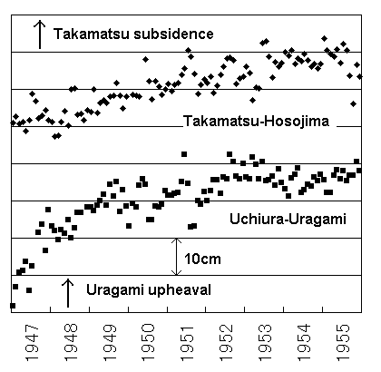
図 高松−細島、内浦−浦神の月平均潮位差変化
高松は南海地震後の9年間に細島に対し約20cm沈降した。この高松の上下変動の時定数は数年程度であり、浦神の隆起の時定数4〜5ヶ月とは明らかに異なる。
|