2000年伊豆諸島北部(三宅・神津)イベント後の中部地方の地殻変動は、2002年春の学会で当時国土地理院の村上氏が
「ドミノ倒し」のようにと表現したものである。引用しようとして予稿を読み直すと、2001年の鳥取県西部地震に
関連させて北陸〜中国地方北部のブロックについて書かれており、地域や着目が異なるため結局引用しなかった。
以下の地震予知連絡会会報にも同じ内容が書かれているが、北陸〜中国地方北部の非定常変位は、
中部地方の非定常変位とつながっており、最初に指摘したことを引用すべきだったかもしれない。
国土地理院, 2003, 2000年7月から10月にかけて西日本において広域イベントが発生していた可能性, 地震予知連絡会会報,
69, 580-588.
要旨
国土地理院GEONETの座標値データを用い,2000年伊豆諸島北部の地震・火山活動時,
およびその後の地殻変動を調べた.その結果,中部関東地域において異なる空間パターン
を持つ3種類の地殻変動が連続的に発生していたことが明らかになった.1つ目の最も顕著
なものは,三宅島と神津島の間の活動に伴うものである.2つ目の地殻変動は中部地方がブ
ロック的に南に変位するもので,伊豆諸島北部の活動の最盛期後に現れた.3つ目は愛知県
から静岡県の沿岸に2001年から目立つようになり現在も継続している東向きの変位である.
このうち,2番目の南向き変位は拡散的で,東海沖のプレート境界に変動源があったと推定
される.
Crustal deformations in the Chubu-Kanto region at and after the 2000
seismo-volcanic activity around the northern Izu islands were investigated using
GEONET coordinate data of the Geographical Survey Institute. We found that three
kinds of crustal deformations of different spatial patterns occurred successively. The
first and the most prominent deformation was the one produced by the seismo-volcanic
activity between Miyake and Kozu islands. The second kind deformation, characterized
by southward displacement of the crustal block in the Chubu district, occurred after the
peak of the first one. The third one is the on-going eastward displacement that became
noticeable in 2001 along the coastal region of Aichi and Shizuoka Prefectures. It is
shown that the second kind deformation was diffusive. We think the temporal change in
the displacement field might have been a viscoelastic response of the crust-mantle
system triggered by the extensive elastic deformation in the Kanto-Tokai region at the
time of the northern Izu islands event.
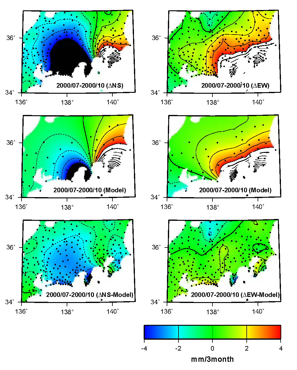
図 関東・中部地域の変位の平滑化
上から順に
・3ヶ月間の非定常変位の分布.
・モデルによる理論変位の分布.黒丸はインバージョンに用いた観測点.
・3ヶ月間の非定常変位からモデルによる理論的な変位を差し引いた残差の分布.
正の値がそれぞれ北向き,東向き変位を示す.
|