私にとって潮位を用いた過去の地殻変動調査のきっかけとなった論文。もともと潮岬測候所勤務だった真砂さんが浦神の地震直前の記録を見つけて大阪管区府県気象研究会で発表し、それを聞いた上司の方が当時の吉田地震情報課長に知らせ、私に話が届いた。結論から言うと、浦神の地震直前の潮位変化が前兆現象であるかどうかは確定的ではない。最大の懸念は、1948年6月の浦神欠測前の潮位上昇に地震直前の記録が似ていることである。浦神は「十九日十時−二十日十時のものが鮮明であるが地震當日の分は全く描き居らず」とあり、12月21日の南海地震まで1日弱の間は欠測だった。
要旨
We examined tide gauge records at stations in and around the Kii peninsula to find if a precursory crustal deformation occurred before the 1946 Nankai earthquake. First, we removed effects of atmospheric pressure and astronomical tide on the records. Then, we tried to get rid of the effects of the oceanic current by taking the difference of the records between two stations. After these corrections we found that sea level at Uragami where is located on the southeastern coast of the Kii peninsula had risen about 10cm just before the Nankai earthquake. The sea level change, if we consider that to represent real subsidence of land near Uragami, could be explained by supposing that a slow fault slip corresponding to moment magnitude 6.9 occurred on the plate boundary in the offing of southeast of the Kii peninsula near the hypocenter of the Nankai earthquake.
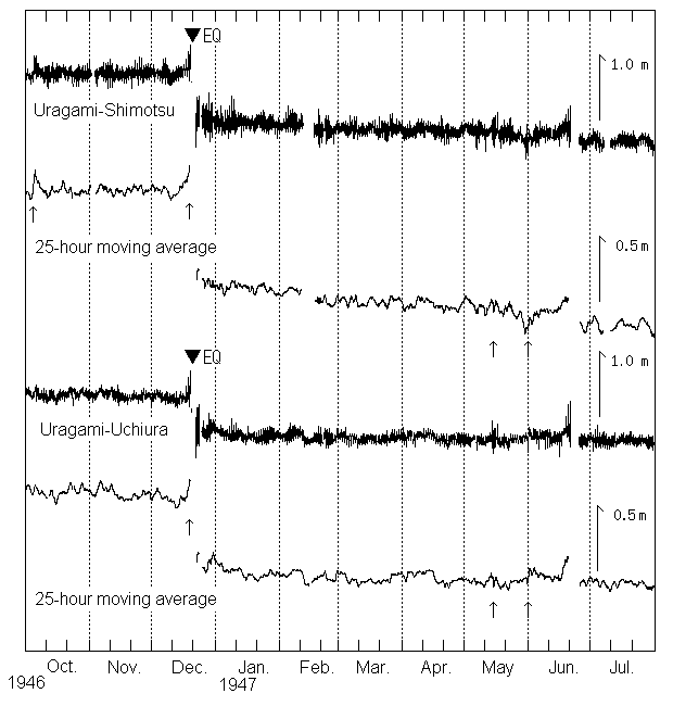
図 1946年南海地震前後の潮位差変化
浦神−下津、浦神−内浦の毎時潮位差変化とその25時間移動平均。地震直前に浦神側の潮位上昇が見られる。
|