要旨
1946年南海地震時およびその後の地殻上下変動の時間的変化を明らかにするため,紀伊半島と四国の潮位記録を詳細に調べた.潮位記録は気圧・潮汐補正を施した日平均潮位を用い,海況の影響を除くために二点間の潮位差をとった.データに対するこのような処理により,紀伊半島の浦神と下津では地震直後の数ヶ月間に顕著な緩和的上下変動が発生していたこと,その余効変動はその後少なくとも数年間は継続したことがわかった.紀伊半島で見られる余効変動と四国西部で見られる余効変動とは時間経過が異なり,両者は別々の余効すべりによって生じたと考えられる.
We examined tide gauge records at stations in the Kii Peninsula and western Shikoku to elucidate vertical crustal deformation at and after the 1946 Nankai earthquake as precisely as possible. First, we eliminated effects of atmospheric pressure and astronomical tide from the data of daily mean sea level. Next, we tried to remove influences of oceanic current by taking differences of the corrected data between two stations. Having conducted those data processing, we found that notable crustal deformation followed after the Nankai earthquake and it lasted several years at Uragami and Shimotsu in the Kii Peninsula. The relaxation time of the deformation differs considerably from that observed in Shikoku (Sagiya, 1999), which suggests that the post-seismic deformation in the Kii Peninsula and that in Shikoku were caused by separate after-slips with different relaxation times.
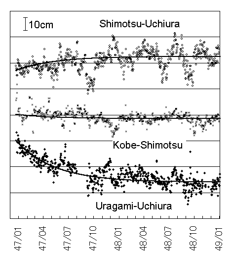
図 1946年南海地震後2年間の潮位差
近似曲線は同じ緩和時間139日の指数関数的減衰曲線。
|